

The Islands of Orkney
A guide to Orkney island by island, from Skara Brae and the Old Man of Hoy to the Churchill Barriers, Westray and North Ronaldsay.
Just off the northern tip of mainland Scotland, across the fast tides of the Pentland Firth, Orkney is a low, green archipelago of about seventy islands, around twenty of them lived on. It is one of the richest places in Europe for prehistory, with Neolithic villages, tombs and stone circles older than the pyramids, and for more than five hundred years it was Norse, ruled by earls who answered to the kings of Norway. Orkney only became part of Scotland in the 15th century, when it was pledged to the Scottish crown in 1468 as part of a royal dowry and formally absorbed in 1472.
Here are the islands, from the Mainland and Hoy to the far north isles.
Mainland: the heart of Neolithic Orkney
The largest island is simply called the Mainland, home to the two towns, Kirkwall and Stromness, and to most of Orkney’s people. Its west is the Heart of Neolithic Orkney World Heritage Site. Skara Brae, a stone-built village lived in from around 3100 to 2500 BC, was uncovered by a great storm in 1850, its houses still furnished with stone dressers and beds. Nearby stand the Stones of Stenness and the Ring of Brodgar, and the chambered tomb of Maeshowe, whose walls carry runes carved by Norsemen who broke into it in the 12th century.

In Kirkwall, the red and yellow sandstone St Magnus Cathedral was begun in 1137 in honour of Earl Magnus, who was killed on the island of Egilsay around 1117 and soon venerated as a saint. Off the north-west corner of the Mainland, the Brough of Birsay is a tidal island with Pictish and Norse remains, reached on foot across a causeway at low tide.
Hoy: hills, cliffs and the Old Man
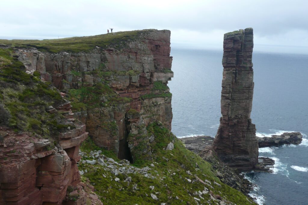
Hoy, the “high island”, is unlike the rest of Orkney: a wild, hilly island whose Ward Hill, at 479 metres, is the highest point in the archipelago. On its west coast, the sea stack of the Old Man of Hoy rises 137 metres from the waves; it was first climbed in 1966, and the climb was shown live on television the next year. Inland lies the Dwarfie Stane, a huge block of sandstone hollowed out as a tomb more than 5,000 years ago.

The south of Hoy looks onto Scapa Flow, the great natural harbour that was the main base of the Royal Navy’s fleet in both World Wars. In June 1919, the interned German High Seas Fleet was scuttled here by its own crews, and 52 ships went to the bottom; a few of the wrecks still lie in the Flow and draw divers from around the world. The naval base at Lyness is now a museum.
In 1991 a Viking boat burial was found eroding out of the shore at Scar, holding a man, a woman and a child, together with a carved whalebone plaque.
The South Isles and the Churchill Barriers
In October 1939 a German submarine slipped into Scapa Flow and sank the battleship HMS Royal Oak. In response, Winston Churchill ordered the eastern entrances sealed, and between 1940 and 1945 four concrete causeways, the Churchill Barriers, were built to link the Mainland to Lamb Holm, Glimps Holm, Burray and South Ronaldsay. Italian prisoners of war worked on the barriers, and on Lamb Holm they turned two Nissen huts into the beautiful Italian Chapel, which still stands.

At the southern tip of South Ronaldsay, the Tomb of the Eagles was found by a local farmer in 1958, a Neolithic chamber that held the bones of people and of white-tailed eagles. Out in the Flow, Flotta is home to an oil terminal, and Graemsay, between Hoy and Stromness, has two lighthouses that guide ships into the Flow. To the south lies Swona, abandoned in 1974, where feral cattle now roam.
Rousay and Eynhallow: the Egypt of the north
Rousay, just off the Mainland, is so packed with archaeology that it has been called the “Egypt of the north”. Along its southern shore lie a string of chambered cairns and brochs, among them Midhowe, a huge stalled tomb now protected inside a hangar-like building. In the 19th century many of its people were cleared from the land to make way for sheep. Across the sound lies Wyre, with the remains of a 12th-century Norse castle.

Between Rousay and the Mainland, Eynhallow, the “holy island”, has a medieval church and some of Orkney’s richest folklore: it was said to be the summer home of the Finfolk, sea people who could make the island vanish beneath the waves.
Westray and Papa Westray
Westray, the “queen o’ the isles”, has cliffs full of seabirds, the ruined 16th-century Noltland Castle, and the village of Pierowall. In 2009 archaeologists at the Links of Noltland found a tiny carved Neolithic figurine, the “Westray Wife”, thought to be the earliest representation of a human face found in Scotland.

From Westray, the flight to Papa Westray is the shortest scheduled flight in the world, scheduled at under two minutes. “Papay” has its own remarkable Neolithic site: the Knap of Howar, two stone houses often described as among the oldest standing houses in northern Europe.
Sanday, Stronsay, Eday and North Ronaldsay
Low-lying Sanday is ringed with white sandy beaches. In 1991 a Viking boat burial was found eroding out of the shore at Scar, holding a man, a woman and a child, together with a carved whalebone plaque. Its striped lighthouse at Start Point dates from 1806. To the south, Stronsay was once a great herring port, and Eday has the Stone of Setter, one of Orkney’s tallest standing stones; it was off Eday, in 1725, that the pirate John Gow ran aground and was captured.

Furthest north of all, North Ronaldsay is famous for its sheep, which are kept on the shore by a great stone dyke that runs right round the island and live almost entirely on seaweed. Its brick lighthouse, built in the 1850s, is the tallest land-based lighthouse in Britain, and beside it stands an older beacon from 1789.
The east: Shapinsay and Copinsay
Shapinsay, a short ferry ride from Kirkwall, is dominated by Balfour Castle, a grand Victorian mansion. Off the east coast of the Mainland, Copinsay is an RSPB reserve with high cliffs crowded with seabirds in summer, and the Horse of Copinsay stands just off its northern tip.

Getting to Orkney and around the islands
Ferries cross to Orkney from Scrabster to Stromness, from Gills Bay to St Margaret’s Hope on South Ronaldsay, and from Aberdeen to Kirkwall, with a passenger ferry from John o’ Groats in summer, and there are flights to Kirkwall from several Scottish airports. Between the islands, Orkney Ferries sails to the North and South Isles, and small planes fly from Kirkwall to the outer isles. Many sites are in the care of Historic Environment Scotland, and some, like Maeshowe, need to be booked in advance. Every island here can be collected in your Island Passport.

Where in the world
23 islands in this article








- Mainland, Orkney Orkney
- Egilsay Orkney
- Brough of Birsay Orkney
- Hoy Orkney
- Lamb Holm Orkney
- Glimps Holm Orkney
- Burray Orkney
- South Ronaldsay Orkney
- Flotta Orkney
- Graemsay Orkney
- Swona Orkney
- Rousay Orkney
- Wyre Orkney
- Eynhallow Orkney
- Westray Orkney
- Papa Westray Orkney
- Sanday Orkney
- Stronsay Orkney
- Eday Orkney
- North Ronaldsay Orkney
- Shapinsay Orkney
- Copinsay Orkney
- Horse of Copinsay Orkney
Read next
All articles →
Islands With an Airstrip: Beach Runways and the World’s Shortest Flight
A runway that disappears at high tide, a flight that takes under a minute, and a helicopter to Tresco: the islands you can fly to.

Islands at War
How war shaped the islands of Britain and Ireland: Scapa Flow and the Churchill Barriers, the occupied Channel Islands, Gruinard's anthrax, island forts and the Iolaire disaster.
