

Vallay
Island Passport
Collect Vallay
Be the first to collect it
Tidal island. Stamps are never worth a risky crossing. Check official safe crossing times and local signs before walking out.
Vallay, in Gaelic Bhàlaigh, is an uninhabited tidal island of around 643 acres off the north coast of North Uist in the Outer Hebrides. At low tide it can be reached across a long expanse of sand, and once it supported a population of nearly sixty people. It is best known as the home of the archaeologist and textile manufacturer Erskine Beveridge, and for its seabirds and prehistoric monuments.
Landscape
Vallay is a low island of machair, dunes and sandy shores, fringed by the vast tidal strand that separates it from North Uist. At low tide the sands stretch for well over a kilometre, shining in the light, and at high tide the sea flows in and Vallay becomes an island again. The north coast of North Uist is one of the most beautiful in the Hebrides, with white beaches, tidal islands and machair rich in wild flowers.
History

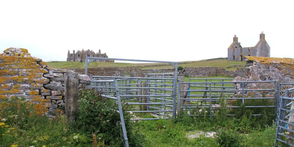
Vallay has a long history, with prehistoric monuments scattered across the island. Its best-known resident, Erskine Beveridge, was a wealthy linen manufacturer from Dunfermline who became a pioneering archaeologist and photographer of the Hebrides, recording many ancient sites in North Uist and Coll. He built a large house on Vallay in the early 20th century, and its ruins still stand. After his death the island’s population dwindled, and today Vallay is uninhabited.
The RSPB reserve at Balranald, on the west coast, is famous for its corncrakes and machair flowers.
More about Vallay

North Uist has a remarkable concentration of prehistoric sites, from Neolithic chambered cairns such as Barpa Langass to stone circles and Iron Age duns. The RSPB reserve at Balranald, on the west coast, is famous for its corncrakes and machair flowers.
Visiting
Vallay can be reached on foot across the sands at low tide from the north coast of North Uist, near Malacleit. The tide comes in quickly across the flat strand, so always check tide times carefully, allow plenty of time to return, and ideally go with local knowledge. You can collect Vallay as a landing or a sighting in your Island Passport.
Wildlife and area
Look out for Oystercatcher, Ringed Plover, Dunlin, Arctic Tern and Corncrake, and for Eurasian Otter, Grey Seal and Harbour Seal. Other islands nearby include Eilean Dòmhnuill, Oronsay, North Uist, Boreray, Lingay and Kirkibost.
Tides
Now
—
Next high water
—
Next low water
—
Not for crossing. These are modelled tide heights, not safe crossing times. Tidal causeways and sands can flood quickly: always check the official safe crossing times and local signs before walking out.
Heights in metres relative to mean sea level; times are UK time. Not for navigation. Tide model: Open-Meteo (CC BY 4.0).
How to get to Vallay
You can reach Vallay on foot.
On foot
You can walk to Vallay at low tide. The way across floods quickly as the tide turns: check the safe crossing times and local signs, and never cross on a rising tide.
Plan your trip
Timetables change, so always check with the operator before you travel. We may earn a commission if you book through some of these links, at no extra cost to you.
Wildlife
45 species recorded on the island
Highlights


All wildlife
Loading all 45 species…
Nothing on the list is usually seen this month.
Recordings from Wikimedia Commons, under Creative Commons licences; hover a Listen button for the recordist. Sightings are records shared with GBIF since 2000.
Watching wildlife responsibly. Keep your distance from seals, seabird colonies and cetaceans, stay quiet, and never feed or chase wildlife. See the Scottish Marine Wildlife Watching Code.


